
Search published articles
Showing 26 results for Tunnel
P Headarian, S. M. Fatemi Aghda, Ali Noorzad,
Volume 7, Issue 2 (3-2014)
Volume 7, Issue 2 (3-2014)
Abstract
Tunneling in complex geological and geotechnical conditions is often inevitable, especially in urban areas. The stability analysis and the assessment of ground surface settlement of a shield tunneling are of major importance in real shield tunneling projects. The objective of this research is to determine the collapse pressure of a shallow circular tunnel driven by a Tunnel Boring Machine (TBM) of the Earth Pressure Balance (EPB) type. In this study, analytical methods and three-dimensional numerical modeling with ABAQUS software were implemented to examine the effect of face pressure on the behavior of the tunnel. The parameters were calculated using data from Karaj subway-line 2 as a case study. The analytical method used in this study is Leca-Dormiex which is based on limit analysis theory. The method is based on a translational multiblock failure mechanism. Also, elastic and Mohr-Coulomb constitutive model have been used for soil behavior. The results of analytical method and numerical modeling were then compared. Based on the obtained results, face pressure assessed from the analytical method of Leca-Dormiex (upper bound) is the minimum pressure that can be implemented on the face tunnel. It also indicates that with implementation of suggested pressure of analytical method, Karaj subway face tunnel is stable and consequently execution of pre-consolidation methods in this section of the tunnel does not seem to be necessary
M Karami, R Bagherpur, D Raisi Gahrooee, L Faramarzi,
Volume 8, Issue 2 (11-2014)
Volume 8, Issue 2 (11-2014)
Abstract
The Sabzkouh water conveyance tunnel, with a length of approximately 11 Km to transferred 90 million cubic meters of water per year from the Sabzkouh area to Choghakhor Dam, about 80 Km south of Shahrekord in Chahar Mahal-e Bakhtiari province is under study. Because of the long length of this tunnel and also low rate excavation by traditional tunneling methods, the Tunnel Boring Machine has been a priority. Due to limitations of TBMs in complex and unfavorable geological conditions, based on the precise study performed, the machine was selected. The geological features and the geomechanical properties of rock masses play an important role to selection of proper TBM. In this paper, by estimation of the most important geomechanical properties and geological conditions of the rock masses, with the interpretations of geotechnical logs and the laboratory test results combined with field observations, the rock mass of the Sabzkouh tunnel, based on the three common engineering systems of RMR, Q and GSI was classified. According to classification systems, the rock masses are divided into three geotechnical zones. Based on the uniaxial strength of intact rock, the properties of discontinuities, fault thickness and shear zones, the underground water level and the squeezing intensity the performance of hard rock TBMs was performed. Finally, double shield TBM for the excavation of Sabzkouh tunnel is proposed
M Taremi, A Eftekhari, M Saeedi,
Volume 9, Issue 1 (6-2015)
Volume 9, Issue 1 (6-2015)
Abstract
This paper presents a case study of the instability mechanism, to verify and reinforcement method adopted construct collapsed zone of Sabzkuh water conveyance tunnel in southwest Iran. The instability problems were encountered during tunnel excavation due to the failure, changes in stress field lead to deformation causing dilation and increasing the permeability of sand and gravel layers, local fault gouge zones, landslide and in turn significant reduction in shear strength and collapse in tunnel. IPE Arch Support Technique (IAST) was, used for T1 part of Sabzkuh tunnel zone in order to reinforce the ground around tunnel and to cross the zone falling. In this study, Finite Element Method was employed for the quantitative reinforcement effect with deformation modulus of ground, IPE length and size. As a result, the settlement increases as length increases and decreases with the increase of the deformation modulus of ground and IPE size.
Gholam Reza Khanlari, Mohammad Maleki, Reza Hydari-Torkemani, Somaye Alipour, Fateme Naseri,
Volume 9, Issue 3 (12-2015)
Volume 9, Issue 3 (12-2015)
Abstract
One of the best approaches to reduce transportation problem is to use the underground tunnels. Therefore, Niayesh highway tunnel was performed by the New Austrian Tunnelling Method (NATM) in the northern part of Tehran and it includes north and south tunnels. The excavation of tunnels and other underground structures cause considerable changes in local stress conditions around structures that lead to surface settlement. In this research, surface settlement has been studied for five sections (CS-1 to CS-5) by empirical methods, numerical analysis and actual settlements. For the empirical and numerical methods, O’Reilly and New (1982) method and also finite element method (PLAXIS2D software) have been used, respectively. On the basis of the obtained results, the numerical method in all sections (except section 3) is in agreement with the actual settlements. While, empirical methods have estimated the settlements more than actual values in those sections. Also, the achieved results from the aforementioned methods show that the maximum settlement due to tunnel excavation is more than allowable settlement and it is in risk condition
Ahmadzadeh, R Bagherpour, Saeed Mahdevari,
Volume 10, Issue 2 (11-2016)
Volume 10, Issue 2 (11-2016)
Abstract
Because most part of Iran country is located in a dry climate, construction of water conveyance tunnels is inevitable. One of the major challenges in the construction of these tunnels is inflow of water into the tunnel during the construction and operation phase. The Rozieh water conveyance tunnel whose length is 3200 meters is a part of water conveyance project to the Semnan city and it is located 30 k NE of Semnan city. In accordance with the drilled boreholes, the tunnel route has been classified into eight zones from the geotechnical view. Then the permeability coefficients of host rock were calculated using back analysis approach on the basis of numerical simulation results and water inflow quantity during the construction phase. A parametric study was done on the lining and cement injection zone permeability and the thickness of cement injection zone. According to this study, the effect of injection zone thickness variation on the water inflow quantity is negligible. So with the assumption of 3 meters thickness for the injection zone, the permeability coefficient of host rock after injection were evaluated. Dependent on the initial rock permeability, cement injection could reduce the rock permeability 10 to 1000 times. In addition, the water inflow into the tunnel was calculated using hydro-mechanical coupling analysis. According to this analysis, the water inflow calculated by the hydro-mechanical coupling analysis is 50 to 70 percent less than the hydraulic analysis.
, , ,
Volume 10, Issue 3 (2-2017)
Volume 10, Issue 3 (2-2017)
Abstract
The Bakhtiari dam has located on Bakhtiari River in province of Lorestan. In order to access the crest of the dam, the excavation of a spiral tunnel is being studied. There are other access tunnels which are branched from this tunnel in different levels and are connected to grout galleries. According to the fact that this tunnel will also be used during the operation of the dam,The correct determination of mechanical parameters of rock masses for tunnel design and stability Analysis is very important. In order to analyse the stability of the underground rock structures, the mechanical and engineering parameters of the rock mass must be known. Accurate rock mass properties can only be obtained from large in situ tests. Such tests are seldom carried out as they are very expensive and time consuming. Sensitivity analysis of parameters can be applied for the optimisation of testing schemes. Sensitivity analysis helps to avoid mistakes due to subjective conjecture. In this article, after the introduction of regional geology and determination critical section on the tunnel path, the mechanical parameters of the rock mass surrounding the tunnel are modelled and analyzed by using FLAC3D software (numerical finite difference method). Parameters conducted in the analysis include the elasticity modulus (E), cohesion of the rock mass (C), friction angle (ϕ), coefficient of lateral stress (K) and tensile strength (&sigmat). Ultimately, according to the result of numerical modelling and parametric analysis, parameters affecting the stability are prioritized. The result of analysis showed that in this project, tensile strength of the rock mass does not affect the stability of the tunnel, and Also, in order of priority, E, ϕ, C, k parameters are important in design. The amount of field tests for rock parameters can be rationalised according to their sensitivity factors.
M. R Baghban Golpasand , M. R Nikudel , A Uromeihy ,
Volume 10, Issue 3 (2-2017)
Volume 10, Issue 3 (2-2017)
Abstract
Ground settlement due to tunneling and the effects of the engineering geological factors on its dimensions and extensions, is a very important problem in shallow tunnel excavation projects in urban areas. Empirical method is one of the usual methods to study this subject. The empirical and dimension-less parameters of VL and k are the most important parameters in relation to this method that are estimated according to engineering geological factors. In this research, the values of these parameters were initially estimated based on preceding studies and the ground settlement was predicted using these estimated values of VL and k. In next stage, the results of predictions were compared with the real (measured) settlements happened due to Abuzar tunnel excavation. As the real settlements are less than the predicted ones, it was concluded that the real VL must be lower than the predicted values or the real k must be higher than the predicted values. With regard to the high dependency of these parameters to the soil cohesion, it seems natural cementation of Tehran alluvia has acted as a factor to increase the soil cohesion and has caused to decrease ground settlement due to excavation of Abuzar tunnel. For validation of this hypothesis, preceding findings about alluvia cementation were reviewed and the results of in-situ and laboratory shear and triaxial tests were compared with together. Then it is concluded that the higher cohesions of in-situ shear tests are occurred due to natural cementation of materials existing in Abuzar tunnel route
, ,
Volume 10, Issue 4 (5-2017)
Volume 10, Issue 4 (5-2017)
Abstract
There are various methods for the analysis of the interactional behavior of the surrounding land, using the lining structure which is the most common method of deigning lining structure tools for the static loads by using the hyper static methods. In recent years, there has been a question that depicts whether this method provides the best results in designing the tunnel structure or not.Due to the nonlinear behavior of the earth surrounding the lining structure, utilizing the lining method could lead to conservative results in the design. If it is possible to somehow find the forces caused by the real behavior of the land surrounding the lining structure influencing the structure and conduct the design based on them, more optimal results would be obtained. This study is based on the actual behavior of the land surrounding the lining structure and the displacement of the structure caused by forces with linear behavior in the static design according to the non-linear behavior of the land around the tunnel structure. The behavior is modeled using the non-linear programs and the forces affecting the lining of the structure will be inference. Also there is a case study based on this method in which the soil interaction with the tunnel analysis and designing the lining structure was first performed and eventually the obtained results were compared with the hyper static method. In this paper, analysis of maintenance system with lower thicknesses considering land-shield, indicated that applying the reinforced concrete with 40cm thickness has the potential to tolerate the applied load but lining with 45cm thickness is capable of tolerating the loads of design and it can be concluded that applying the simulation method combined with the soil and structure besides considering the nonlinear behavior of the soil leads to more economical results in a project.
Majid Taromi, Maziar Hosseini, Seyed Mahdi Pourhashemi, Majid Sadeghi,
Volume 11, Issue 1 (8-2017)
Volume 11, Issue 1 (8-2017)
Abstract
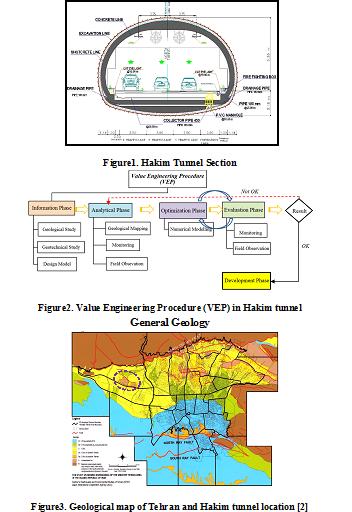
./files/site1/files/3Extended_Abstract.pdfExtended Abstract
(Paper pages 51-72)
Introduction
Value engineering is considered an efficient alternative to improve design and construction process of urban tunneling projects. Application of value engineering techniques can provide investigating all aspects of a project in a team work, creative and short-time manner which contribute to precisely identify a project’s quality improvement issues, construction time and costs.
Hakim Expressway one of the capital's main highways in Tehran metropolis with 9 Km in length, starts from the junction of Resalat expressway and Kurdistan expressway after Resalat tunnel and ends in Lashgari expressway. The west extended this highway passing through the area of Chitgar forest park. Due to environmental constraints, the Hakim twin tunnels with cross-section of 186 m2 excavation areas and total length of 3256 m to the NATM/SEM method in this area were excavated (Figure 1).
In preliminary design of Hakim tunnel project, on category of excavation and support system was suggested. During the tunnel’s excavation operation, the behavior and classification of the tunnel were investigated from field observation, instrumentation and monitoring of geological models and subsequently, further excavation process was modified in accordance with value engineering. The aim of using value engineering approach in this project was to reduce the costs without any decrease in quality, employer satisfaction along with minimum risk and as well as improving operational and practical aspects. Ultimately, establishment of the value engineering approach on Hakim tunneling project leads to 10% reduction in construction costs as well as relevant quality with the least challenges (Figure 2).
General Geology
The city of Tehran is founded on Quaternary alluvium, which has been geologically classified by Rieben [1]. The city is located at the foot of the Alborz mountain range, which is basically composed of Eocene pyroclastic deposits (green tuff) and other volcanic rocks. The geology and the morphology of the Tehran region is similar to that for other cities located at the foot of mountains.
Rieben (1966) divided the Tehran coarse-grained alluvia into four categories, identified as A, B, C and D, where A is the oldest and D the youngest (Figure 3).
Hakim tunnel project locates on foothills of northern Tehran, crossing the hills of Chitgar forest park. Results of field surveys indicate that alluvial deposits in tunnel track belong to C (ramps and tunnel portal) and A formations (in most parts of tunnel track).
Geotechnical characterization
Table1 summarizes soil input parameters. Two soil types were considered for the model with 8- meter-height overburden. First layer (No.1) starts from surface with a 1 meter thickness. Second layer (No. 2) has 7 meter thickness.
Table1. Summary of the geotechnical parameters
| Parameter | Unit | Layer No. 1 | Layer No. 1 |
| Internal friction angle (CU) | Deg. | 29 | 33 |
| Cohesion (CU) | Kg/cm2 | 0.15 | 0.45 |
| Density | Kg/cm3 | 18.5 | 20 |
| Poisson ratio of unloading/reloading | Kg/cm2 | 0.2 | 0.2 |
| Secant deformation modulus | Kg/cm2 | 550 | 900 |
| Power of stress level of stiffness | 0.5 | 0.5 | |
| Stiffness unloading | Kg/cm2 | 1650 | 2700 |
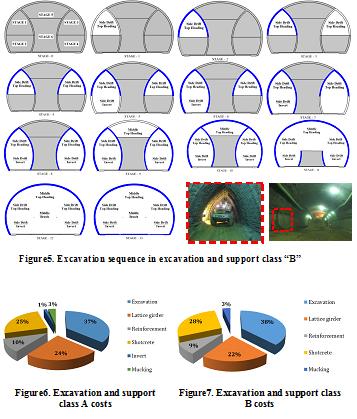
Detailed analysis before excavation and continuation of studies led to two excavation and support classes purposed for Hakim tunnel. Both classes of excavation and support due to ground conditions are modeled and analyzed using software Plaxis. For verification, the results of numerical analysis using monitoring and field observations were compared during the tunnel excavation. The results of monitoring compliance with the results of numerical analysis were appropriate.
Implementation and construction costs were calculated for different sections of two excavation and support classes in accordance to contraction documents to evaluate the effect of optimization in design (Figures 6, 7)
.jpg)
Figure4. Excavation sequence in excavation and support class “A”
Results
Results indicate that in both classes maximum costs are related to excavation section while minimum costs are for invert and mucking. In all concrete spray operations there was just a %3.5 increase in costs. Overall savings in excavation and support was about %10 which is significant (Figure 8).

Figure8. Savings percentage comparison in excavation and support classes A and B
Masoud Zare Naghadehi, Seyed Davood Mohammadi, Mostafa Karimi,
Volume 12, Issue 2 (10-2018)
Volume 12, Issue 2 (10-2018)
Abstract
Introduction
The selection of the best subsurface exploration methods corresponding to geotechnical, topographical and economic circumstances of the project is one of the most effective factors in the success of a tunneling project. On the other hand, the development of a decision model and consequently choosing the most suitable alternatives are complex tasks. Therefore, prioritizing and selecting the best subsurface exploration methods, as the main aim of this study, can reduce the economic and social costs associated with the execution of a tunneling project. For this purpose, ten experts from tunneling community have been asked to weigh the chosen criteria of the problem in this research. A methodology utilized in this study is the Analytical Hierarchy Process (AHP) which proved useful in engineering decision-making problems. The other method is TOPSIS, one that has continuously been used in decision making in the recent decades. These two techniques have been combined and utilized in this work to rank the aforementioned exploration methods.
Material and methods
The study area is located about 109 km far from Shahrekord city amid the Zagros mountains. The Sabzkooh tunnel development plan has been under evaluation in the time that this research was being done. The geology of the area majorly encompasses sedimentary rocks which have been outcropped as folds, faults, and fractured and altered zones. However, the variety of the lithological units in the tunnel route is high, and units of limestone and shales also exist over the path.
In the first step, geological and topographic maps were produced for the study area, and general information from the tunnel path was collected and examined. Suitable exploration methods were evaluated, and six main methods were chosen to be considered as the alternatives of the study including (a) discontinuities study, (b) Lugeon tests, (c) RQD, (d) Geo-electric, (e) Gravimetry, and (f) Seismic methods. Moreover, nine criteria ranging from “volume of the available information” and “environmental impact” to “cost” and “accuracy” of the employed methods were taken into account. A pairwise comparison matrix was then developed, and the experts were asked to fill it out. The importance of each criterion was then simply calculated through this matrix. Alternatives pairwise comparison matrices were also filled out and, in this manner, the alternatives could be ranked using the AHP technique. Next, the TOPSIS technique was employed for the same purpose using a rather different process.
Results and discussion
Both AHP and TOPSIS techniques show very close results for ranking of the alternatives in this study. They rank the three Seismic, Geo-electric and Discontinuities studies methods as the best ones for the considered tunneling project. The only difference between these two techniques is how they determine the worst method. The AHP ranks the Lugeon as the last rank among the six methods whereas the TOPSIS determines the RQD as the least reliable method of exploration for the Sabzkooh tunnel project.
Conclusion
The prioritization and the subsequent selection of the most reliable exploration methods for an underground excavation project is a crucial task amid technical decisions. In this research, two major multi-criteria decision-making methods including AHP and TOPSIS were considered and applied for the Sabzkooh tunnel in Iran. The results indicate a high agreement between the two methodologies even though these two approaches decide differently on the least reliable methods to be applied.
Ako Daraei, Shokrollah Zare,
Volume 12, Issue 4 (12-2018)
Volume 12, Issue 4 (12-2018)
Abstract
Introduction
It is very important to have knowledge on the rock deformation modulus when designing geotechnical structures and modeling oil reservoirs. In general, there are two destructive or static and non-destructive or dynamic methods for determining the rock deformation modulus, but considering the time and cost of destructive methods proportionate to the depth, it is more common to make use of non-destructive approaches. The outcrops of Asmari Formation are widely spread in the west and southwest of Iran, and many engineering projects have been constructed or are being studied on this formation. Therefore, it is of great importance to study on the geomechanical characteristics of this formation. Presentation of empirical relations regarding the relationship between static and dynamic moduli, with respect to the studies carried out in other parts of the world and the dispersion and independence of studies done on Asmari Formation due to its large extent on one hand and the importance of this formation in terms of oil and development civil projects on the other hand, necessitate presenting a comprehensive criterion resulted from all studies carried out on Asmari Formation which can express the relationship between the static and dynamic moduli. This paper represents the relationship between the dynamic and static moduli of the site using the moduli obtained by the down-hole geophysical method and the static moduli obtained by the intact rock test results of Ghalajeh tunnel located in Asmari Formation in Ilam province. Then, a comprehensive relation is presented to express the relationship between static and dynamic modulus by studying the previous researches and criteria on this formation.
Material and methods
Two sets of tests were conducted to determine the relationship between static and dynamic moduli in the Ghalajeh tunnel. First, a uniaxial compression strength test was performed on 13 cores taken from three boreholes to compute the elasticity modulus in accordance with ISRM standard. Then, down-hole test was conducted on two boreholes such that to determine the dynamic modulus using compressive and shear wave velocities. Seismographic apparatus of ABEM RAS 24 as well as three-component down-hole geophones were utilized in order to plot the seismic profile. After the performing the tests, the dynamic modulus of deformation was calculated using the velocity of P-waves and the density of the host rock.
Discussion and Conclusions
By conducting in-situ static and dynamic laboratory tests on Ghalajeh Tunnel project and determining the values of the static and dynamic deformation moduli, a relation was presented between them. Then, taking into consideration the previous models studied in Asmari Formation, a comprehensive criterion was presented for wider use in the mentioned formation. Given the root mean square error (RMSE) and variance account for (VAF), the values predicted using the proposed comprehensive model have acceptable accuracy. In the interim, the correction factor between dynamic and static moduli in Asmari Formation was between 0.8 and 2.4. The results show that, in general, the relationship between static and dynamic moduli is linear up to a certain range (static modulus of 100 MPa) and then it has a power trend./files/site1/files/124/4darai%DA%86%DA%A9%DB%8C%D8%AF%D9%87.pdf
Ehsan Dadashi, Ali Noorzad, Koroush Shahriar, Kamran Goshtasbi,
Volume 12, Issue 4 (12-2018)
Volume 12, Issue 4 (12-2018)
Abstract
Introduction
Pressure tunnels in hydroelectric plants are used to convey water to powerhouses. These tunnels are the sources of seepage flow to the rock formation, thus, during the water filling, they will have a low resistance to seepage and, by increasing the internal water pressure of the tunnel, the inflow force will be transferred to the rock mass. In these conditions, the cracks, pores and all other elements of the rock mass are affected by the seepage forces in all directions. This hydro-mechanical interaction affects changing the stresses and displacements of the rock mass around the tunnel and causes modifications in the permeability of rock elements during the water filling. Therefore, changes in stress distribution lead to alterations in the permeability coefficient and redistribution of the seepage field. In these conditions, since the analytical solution of the problem is not possible, the numerical analysis based on the finite element method has been used in this study.
Material and methods
In this approach, the rock mass is considered as an equivalent continuum in which the effects of discontinuities are taken into account in its material behavior. High-pressure tunnels under internal water pressure requires reinforced concrete lining to prevent hydro-fracturing. The ABAQUS software is capable of analyzing such as seepage from the tunnel, modeling of the steel bars in concrete, and taking into account hydro-mechanical interaction. Thus, the software is used for numerical analysis.
The pressure tunnel of the Gotvand dam and hydroelectric power plant (HPP) scheme is taken as a case study for the numerical simulation. Pressure tunnel of the Gotvand dam located in the southwest of Iran is taken as a case study for the numerical simulation. Among behavioral models in the software, Mohr-Coulomb failure criterion is considered to describe the rock mass, but the principle of effective stress determines the rock mass behavior. Since the concrete lining of the pressure tunnel will undergo two mechanisms of the cracking due to tension and the crushing due to compression, concrete damaged plasticity model is used to predict the response of the concrete elements. The evolution of the yield surface of the concrete lining is also controlled with tensile and compressive equivalent plastic strains, correspondingly.
In this study, the hydro-mechanical interaction is implemented based on the analysis of the pore fluid/deformation analysis, and the direct-coupled method is used to solve the governing equations of the problem. To verify the proposed model, the elastic behavior of the media is simulated to compare the numerical and the analytical solutions and good agreement is obtained. The numerical analyses are carried out the hydro-mechanical interaction with constant permeability coefficient. When cracks develop in the concrete lining at high water pressure, the properties of the concrete lining change and as a result, the stress dependent permeability of the lining and surrounding rock mass in pressure tunnels should be considered. The coefficient of permeability controls the rate of seepage flow in porous and fractured media. Although permeability represents an original property of the porous media, it can be modified when subjected to the stress variations. Instead of changing aperture, the change in the void space or volume is the typical consequence that results to change the permeability coefficient. In order to bring the model closer to the real conditions and in the validation of the new model, the influence of the permeability coefficient variations of the concrete and rock mass on the deformations and stresses of the model has been added to nonlinear analysis by USDFLD code. Increasing the water head in the tunnel during water filling is also considered with the combination of DLOAD and DISP codes in the model.
Results and discussion
Since the lining and rock mass have nonlinear properties and complex behavior, for verification of the model in ABAQUS software, the model is simulated with homogeneous, isotropic and elastic behavior. The results of seepage flow on the interface of the concrete lining and rock mass obtained by analytical and numerical solutions indicate that there is a ±5 % difference between them. Then, the results of the elastic behavior of the model show a good agreement with the results of analytical solutions. Therefore, this numerical model has been employed for the nonlinear analyses.
Finally, the optimal thickness of the concrete lining with the appropriate arrangement of the reinforcement in the reinforced concrete linings is utilized to minimize water losses from the tunnel based on the new model. Thus, the results of the analysis with the aim of reducing the water losses from the tunnel indicate that the suitable arrangement of the steel bars in the concrete lining leads to the distribution of micro cracks in the lining, and the reinforcement stress stays at a lower value with high internal water pressure. Based on the new numerical model, it is suggested that the lining should be designed with the thickness of 40 cm and the reinforcement with the diameter of 16 mm and the spacing of 20 cm.
Conclusion
The results of the numerical model indicate that to control the seepage outflow from concrete-lined pressure tunnels, the thickness of the lining and the suitable arrangement of the steel bars in the concrete lining play a significant role in preventing excessive seepage from the tunnel./files/site1/files/124/3dadashi%DA%86%DA%A9%DB%8C%D8%AF%D9%87.pdf
Hadi Fattahi, Zohreh Bayatzadehfard,
Volume 12, Issue 5 (12-2018)
Volume 12, Issue 5 (12-2018)
Abstract
Maximum surface settlement (MSS) is an important parameter for the design and operation of earth pressure balance (EPB) shields that should determine before operate tunneling. Artificial intelligence (AI) methods are accepted as a technology that offers an alternative way to tackle highly complex problems that can’t be modeled in mathematics. They can learn from examples and they are able to handle incomplete data and noisy. The adaptive network–based fuzzy inference system (ANFIS) and hybrid artificial neural network (ANN) with biogeography-based optimization algorithm (ANN-BBO) are kinds of AI systems that were used in this study to build a prediction model for the MSS caused by EPB shield tunneling. Two ANFIS models were implemented, ANFIS-subtractive clustering method (ANFIS-SCM) and ANFIS-fuzzy c–means clustering method (ANFIS-FCM). The estimation abilities offered using three models were presented by using field data of achieved from Bangkok Subway Project in Thailand. In these models, depth, distance from shaft, ground water level from tunnel invert, average face pressure, average penetrate rate, pitching angle, tail void grouting pressure and percent tail void grout filling were utilized as the input parameters, while the MSS was the output parameter. To compare the performance of models for MSS prediction, the coefficient of correlation (R2) and mean square error (MSE) of the models were calculated, indicating the good performance of the ANFIS-SCM model.
Milad Masomi Aghdam, Mehdi Hosseini,
Volume 12, Issue 5 (12-2018)
Volume 12, Issue 5 (12-2018)
Abstract
In the mechanized boring method, the factors affecting ground surface settlement can be mainly divided into five categories: geometric, geomechanic, boring machines working, operating and management parameters. In urban tunnels bored mainly in shallow soil bed, face pressure can be one of the factors preventing ground settlement. The Line A tunnel in Qom metro project is bored with an EPB (Earth Balance Pressure) mechanized boring machine. The effect of face pressure on ground surface settlement was analyzed in the present study according to five sections of the tunnel. These five sections were selected in different kilometers of the tunnel where settlement gauges were installed and the results could be validated. To investigate the effect of face pressure on maximum ground surface settlement, four pressure levels of 100 kPa, 150 kPa, 200 kPa, and 400 kPa were taken into consideration. These were 1, 1.5, 2, and 4 times of the initial face pressure level, respectively. The ground surface settlement was assessed at four pressure levels using the finite element software, PLAXIS 3D TUNNEL. The results were validated using ground-level instrumentation (settlement gauges) on all sections. The validation showed that the modeling results are in good agreement with the results obtained from settlement gauges. Comparison of the results indicated that a 4-fold increase in the face pressure led to a maximum decrease of 4.45 mm in the maximum settlement. Therefore, an increase in the face pressure can reduce settlement, although quite minimally. It was also found that an over-increased face pressure (face pressure over 200kPa) not only did not reduce the maximum ground surface settlement but also may lead to passive failure or uplift of ground surface ahead of the shield.
, ,
Volume 12, Issue 5 (12-2018)
Volume 12, Issue 5 (12-2018)
Abstract
In urban areas, it is essential to protect the existing adjacent structures and underground facilities from the damage due to tunneling. In order to minimize the risk, a tunnel engineer needs to be able to make reliable prediction of ground deformations induced by tunneling. Numerous investigations have been conducted in recent years to predict the settlement associated with tunneling; the selection of appropriate method depends on the complexity of the problems. This research intends to develop a method based on Artificial Neural Network (ANN) for the prediction of tunnelling-induced surface settlement. Surface settlements above a tunnel due to tunnel construction are predicted with the help of input variables that have direct physical significance. The data used in running the network models have been obtained from line 2 of Mashhad subway tunnel project. In order to predict the tunnelling-induced surface settlement, a Multi-Layer Perceptron (MLP) analysis is used. A three-layer, feed-forward, back-propagation neural network, with a topology of 7-24-1 was found to be optimum. For optimum ANN architecture, the correlation factor and the minimum of Mean Squared Error are 0.963 and 2.41E-04, respectively. The results showed that an appropriately trained neural network could reliably predict tunnelling-induced surface settlement.
Vahid Shirgholami, Mahdi Khodaparat, Abolghasem Moezi,
Volume 14, Issue 4 (12-2020)
Volume 14, Issue 4 (12-2020)
Abstract
Introduction
Excavation in urban areas occasionally is accompanied by the improper performance of the support system for even small deformations. In this regard, deformation control design based on force-based approaches provides a more realistic reprehensive of excavation performance. Top-down deep excavation techniques are among the modern excavation stabilization methods in urban areas. In this method, unlike the conventional methods, it is possible to perform the excavation and construction operations simultaneously. The present study aims to investigate excavation stabilization using the main structure through the top-down approach. For this purpose, field and numerical evaluations of the stabilized project were conducted based on the top-down approach in the downtown of Qom city, Iran. This research reports the information obtained through monitoring and modeling using the finite element ABAQUS software, predicting the occurred deformations until the end of excavation operations using the calibrated model, and offering an initial estimation of the required stiffness for the support system with respect to the lateral deformations in four sites proposed, according to the studies of Line A Qom Subway.
Project specifications
Based on the geological studies of Line A Qom Subway Tunnel, the geological layers are classified into four soil classes. Qc-1 consists of gravely sand with fine content of 5 to 20%; Qc-2 is silty and clayey sand with fine content of 35 to 60%; Qf-1 is clayey silt with fine content of 60%; and Qf-2 is a silty clay layer with fine content above 60%. Line A of Qom subway passes the study area of the present study, which is located in Ammar e Yaser Street (Station A6). Based on the geotechnical studies of the project site, the site in the levels near the ground consists of Qc-2 but in the lower elevations, it is composed of Qc-1 and Qf-2.
Salam Trade Complex, located in the downtown of Qom city, has 6 underground stories and 6 above-ground stories. It is limited to the main street in the south and to urban decay in the three other directions. The final excavation depth, length, and width is -21, 36, and 32-52 m, respectively. The project structure consists of a steel moment frame with a retaining wall in the negative elevations and metal deck frame for ceiling construction. In this project, excavation wall deformation was monitored in three important sections (A, B, and C). Due to the vicinity to urban decay, a total station TS02 was used for monitoring these sections. According to the field surveys, the maximum horizontal deformation of the walls in sections A, B, and C is 24.10, 42.16, and 47.21 mm, respectively, which were measured in the 0, -1.5, and 0 m elevations.
Monitoring process and numerical simulation
To calibrate the prepared model, a sensitivity analysis was performed on geotechnical parameters including modulus of elasticity (E), internal friction angle (φ), and cohesion (C) of the layers by simulating 60 numerical models. Based on the sensitivity analysis results, an increase in internal friction angle and elasticity modulus for layer 1 (i.e., φ1 and E1) and elasticity modulus of layer 3 (E3) results in a decrease in lateral deformation. Finally, using the sensitivity analysis results and after several trials and errors, the numerical models for sections B and C were calibrated when reaching the depths of -8 and -11 m, respectively. Using these models, then, it is possible to predict deformations up to the end of the project.
To determine the required stiffness for the excavation support system, regarding the acceptable deformation of the adjacent soil mass, 160 numerical models were built and their results were analyzed. Based on the results of Brason and Zapata (2012), relative stiffens (R) were used to develop a relationship between the maximum lateral deformation of the wall and the required stiffness of the support system. R is a dimensionless parameter that represents the stiffness of a solid support system; the greater this value is, the more flexible the system would be. In this study, caisson pile length, excavation width, and buried depth of the wall were used for determining the R.
R =
 (1)
(1)Figure 2 presents the maximum occurred deformation in terms of depth versus the relative stiffness for sites QC and QF.


Figure 2. Maximum deformation in terms of depth versus the relative stiffness for sites QC and QF
Conclusion
- According to the monitory data, the maximum lateral deformation in sections B and C until the end of the project was 42.16 and 47.2 mm, respectively. Moreover, the deformation of the other points inside the excavation was 30 mm.
- Considering the occurrence of maximum lateral deformations in the higher elevations in the monitored sections, it is inferred that excavation support at the ground level plays a key role in this approach. Hence, the lack of completing the structural frames and slabs for facilitating the excavation operation can lead to an increase in deformation levels.
- Based on the prepared graphs, the top-down approach in sites QC-2 and QF-2, compared to sites QF-1 and QC-1, provides a more desirable performance for deformation control.
Mohadeseh Sadeghi, Naser Hafezi Moghads, Mohammad Ghafoori, Mehrdad Amiri, Ali Bashari,
Volume 16, Issue 2 (9-2022)
Volume 16, Issue 2 (9-2022)
Abstract
The design of underground or terrestrial structures on the rock bed depends on the physical and mechanical properties. Considering the mining method in Tabas coal mine extraction method is long and destructive, the evaluation of the geomechanical properties of the rocks is more necessary. In this research, the characteristics of the rock units of the eastern tunnel No. 3 of Tabas coal Pervadeh mine were investigated. In this study, 3 samples of shale, sandstone and mudstone were examined. Considering the importance of the subject in this research, new experimental relations have been proposed, and their application shows desirable results. In order to obtain geomechanical characteristics and empirical relationships, physical tests such as porosity, water absorption percentage, unit volume weight, and mechanical properties such as uniaxial compressive strength, point load index, Brazilian tensile strength, direct cutting test, durability and brittleness index were carried out. To achieve the desired objective, the most appropriate relationships are presented using the regression method. Statistical analysis shows good correlation between different parameters in shale, sandstone and mudstone samples.
Massoud Morsali,
Volume 17, Issue 3 (12-2023)
Volume 17, Issue 3 (12-2023)
Abstract
Tunneling in a saturated environment and the intrusion of groundwater flow into tunnels during excavation is one of the most serious problems in tunneling projects. Water ingress into the tunnel can lead to damage to tunnel construction equipment, personnel, the excavation process, etc. The hydrogeological studies of the springs along the tunnel route and the estimation of the water entering the tunnel also investigate the possibility of drying up or reducing the water level of the tunnel route. The hydrogeological studies of the springs along the tunnel route and the estimation of the water inflow into the tunnel will also examine the possibility of drying up the springs or reducing the water level of the tunnel route. On the other hand, the complications of water ingress into the tunnel and the lack of an accurate and appropriate method increase the importance of these studies. Experimental and analytical methods are available to predict water inflow into a tunnel. In this article, in addition to presenting the general process of carrying out hydrogeological studies of tunnels, the weight percentage of hydrogeological studies and the problems associated with them are discussed. On average, more than 30% of all tunnel problems are related to groundwater, but less than 5% of studies are carried out in this field. The disproportionate weight of the above two cases and its causes are among the other cases discussed in this article.
Professor Hamidreza Nassery, Koosha Tamimi, Dr Farshad Alijani, Dr Sadegh Tarigh Azali,
Volume 17, Issue 3 (12-2023)
Volume 17, Issue 3 (12-2023)
Abstract
The development of underground transportation activities in cities, such as tunnel boring, may exert short-term or long-term effects on the groundwater and springs of such areas. The construction of the tunnel of Tehran Metro Line 6 (TML6) through alluvium and carbonate rocks of Ali Spring has aroused concern due to the caused fluctuations in discharge and temporary dryness of the spring. The hydrochemical properties of the groundwater and catchment area were investigated to find a connection between the aquifers around the spring and determine the major aquifer feeding it. The estimated volume of water penetrated to the tunnel and the most greatly affected area by the water leakage into the tunnel was determined using analytical methods of water leakage into the tunnel and the DHI method. The statistics for precipitation with the changes in the discharge of the spring before and after the excavation of the metro tunnel were compared to evaluate the changes in the discharge of the spring with the precipitation in the area. The results showed that the metro tunnel excavation has dramatically affected the hydrological system of the area and discharge of the Ali Spring. Moreover, continuing the extraction may produce adverse effects on the discharge of other springs and wells and alter the flow system of the area temporarily or forever.
M.sc. Behrooz Margan, Dr. Davood Fereidooni,
Volume 18, Issue 1 (5-2024)
Volume 18, Issue 1 (5-2024)
Abstract
In this research, various aspects of the rock burst phenomenon in the Haji-Abad tunnel site in the Hormozgan province have been discussed. Considering that the tunnel site is located in an active tectonized environment in terms of geological conditions and the depth of the tunnel in some parts reaches more than 100 to 253 m, and also considering the variety of rocks in the tunnel site, which are massive rocks with high strength up to broken fault zones, the importance of studying and investigating the phenomenon of rock burst is very important for the safety of the labor force and equipment and the stability of the underground space. For this purpose, the Haji-Abad tunnel site has been divided into ten units of engineering geological conditions using the BGD method, which includes eight units T1 to T8 and two crashed zones Tf1 and Tf2. Then, using common experimental and semi-experimental methods, the phenomenon of rock burst in the tunnel site has been evaluated. In the experimental procedure, Goel et al.'s criterion was used, according to which the rock burst phenomenon does not occur in any of the tunnel units. Using semi-empirical methods, including the criterion of linear elastic energy of the tunnel site units in the range of very low to moderate rock burst phenomena and using the tangential stress criterion, the site units in the medium to very high range and based on the stress criteria of these units in the moderate to high range and finally, using the fragility criterion, all site units are placed in the range of high rock burst.
Related Websites
Site Keywords
نشریه, Academic Journal, Scientific Article, کلمه شماره یک, کلمه شماره یک, کلمه شماره یک, کلمه شماره یک, کلمه شماره دو, کلمه شماره یک, کلمه دوVote

© 2024 CC BY-NC 4.0 | Journal of Engineering Geology
Designed & Developed by : Yektaweb